Between 2005 and 2007, there was much discussion before changing the severe thunderstorm criteria for hail from 3/4-of-an-inch diameter to 1-inch diameter, or from the size of a penny to a size of a quarter. It doesn't seem that much of a change, but it is considering that damage to a house from hail starts somewhere around 1 1/4-of-an-inch in diameter.
Also, it was thought that Severe Thunderstorm warnings issued by local National Weather Service Offices were quite numerous and that by forecasting for the slightly larger hail, there wouldn't be so many severe thunderstorm warnings issued during the spring and summer months.
The graph below shows the difference in the number of hail reports annually since 1955 through 2012. Outside of the years before 1996, the number of 3/4-inch hail reports outnumbered 1-inch hail reports until 2007.
- Annual number of 3/4-inch and 1-inch hail 1955-2012.

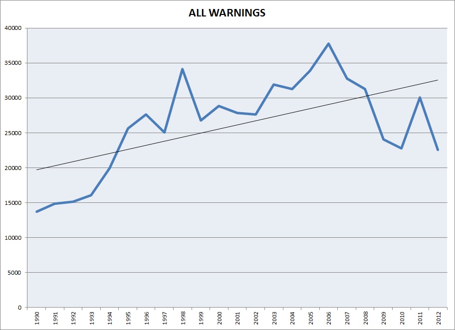
Does the change in hail criteria change the number of warnings issued nationwide? Let's look at a plot, first, of total warnings since 1990. We'll look at combined tornado and severe thunderstorm warnings since there is not a specific designation for hail warnings.
- Plot of combined tornado and severe thunderstorm warnings during the modern era 1990-2012. Black line is the trendline.
- Number of severe thunderstorm warnings from 2007 through 2012.

This could lead to the conclusion that changing the severe criteria to 1-inch diameter hail did decrease the number of warnings. But, one must consider that 2011 was an unusually active year for tornadoes and severe storms. Plus, damaging winds also plays a role in the issuance of severe thunderstorm warnings. Convective winds of 50 kt (58 mph) or better meets severe criteria, as does wind damage. Damage to large trees and outbuildings makes for a large array of considerations to issue severe thunderstorm warnings.
No comments:
Post a Comment