Thursday, February 18, 2021


Below is an additional display of tornadoes that occurred between 1980-2019. Climatology shows that many of the tornadoes occurs from Texas eastward into Georgia and Florida. and northward into Tennessee and Kentucky, weighted by the February 5-6, 2008, or the Super Tuesday Outbreak.


Wednesday, February 17, 2021

 February Tornadoes Are Not That Rare

Dan McCarthy
former Storm Prediction Center Warning Coordination Meteorologist
and former Meteorologist in Charge NWS Indianapolis


Over the past few weeks, it has been reported over many national news outlets that February tornadoes are rare occurrences. Let's stop this right now, they are not that rare. When I worked at the National Severe Storms Forecast Center/Storm Prediction Center, it was understood that when we got to February 15, it was time to get into tornado season frame of mind! Florida, Georgia, Alabama and Mississippi were the usual states, especially Florida, that started the season.

Look at the number of tornadoes for each February going back to 1950 in Figure 1 below using the SPC tornado database.


Analysis of the SPC database shows that actually having a low number of tornadoes (less than 10) is rare!  Who cannot forget the Super Tuesday Tornado Outbreak across the Ohio Valley in 2008! This outbreak occurred February 5-6, 2008 producing 86 tornadoes and resulting in 44 fatalities. 

In 2008, there was 148 confirmed tornadoes in February! Since 1950, February averages 27 tornadoes per year! In fact, just since 1980, the U.S. has averaged 32 tornadoes each February.

Tornado awareness is an issue in February. Tornadoes can happen any time during the year, anywhere. But, there is still the stigma that tornadoes mainly occur in the months of April, May, and June. This too is true since that is when most tornadoes occur in the year. But, in a safety and preparedness aspect, preparedness and being StormReady for tornadoes must be emphasized in months not "known" for tornadoes, or when major weather patterns like we have had lately are present.

Given the 8-14 day projection from the Climate Prediction Center, there will be a rapid change from the latest Arctic air that has entrenched much of the central and southern Plains into the southeastern U.S. Given this change, monitor the Storm Prediction Center for the latest outlooks as severe weather season could be starting in later February into early March.


Wednesday, April 1, 2020

APRIL NATIONAL TORNADO CLIMATOLOGY


In bringing back my blog, "Caught in the Updraft", here are some graphics c/o NWS Storm Prediction Center data to start off April.


Above is a plot of April tornadoes by year since 1960. The Aprils that standout are the ones with Super Outbreaks. Those would be the  April 3-4, 1974, and April 27-28, 2011.


This is a plot of number of tornadoes by State for the month of April 1950-2018. The only reason 1950-1959 is included is that i honestly could not get Microsoft Access to work for me from 1960-2018 without having to add all 59 years together.  Naturally, Texas, Oklahoma, and Kansas show up being in Tornado Alley. But, notable is the high counts in Illinois compared to Arkansas, Mississippi, and Alabama given the April 2011 outbreak. This could be because of the Palm Sunday outbreak the 11th and 12th of 1965. Illinois was a small part of the 1974 Super Outbreak that included 13 states, but mostly from the lower Great Lakes through the Ohio and Tennessee Valleys, and Mississippi, Alabama, and parts of Georgia.

The distribution of F/EF-Scale values assigned to damage from April tornadoes, again from 1950-2018. Note that those assignments prior to 1977 are estimated since the Fujita Scale was not required for each tornado until that year when the Verification Unit  started as part of the National Severe Storms Forecast Center (now the NWS Storm Prediction Center). There were some tornado damage evaluated prior to 1977, like April 3-4, 1974, but only those done by Fujita and his team and published by Fujita through his works.  Notable is first the 1.77% defined as F-9 or unknown. Around 73% are considered weak tornadoes causing F/EF0 or F/EF1 damage. The remaining 27% being assessed as strong or violent.

Which brings us to tornado fatalities, again from 1950-2018. Deaths, of course, occur with the more violent tornadoes (F/EF 4 and 5) with 72% and nearly 98% occurring with damage rated F/EF2 or greater.


Friday, January 30, 2015

A Winter Storm Watch for Central Indiana beginning at 7 pm Saturday through 7 am Monday morning


How interesting that a winter storm is moving towards Indiana just in time for Groundhog's Day.  The NWS has issued a Winter Storm Watch for late Saturday into Monday morning rush hour.


So, I can see the writings now about the Winter Storm Watch.  This is somewhat a different "watch" than in the spring and summer as with Severe Thunderstorm Watch which indicates that conditions are favorable for severe thunderstorms.

A Winter Storm Watch is meant to tell you to watch out for a Winter Storm during the latter half of this weekend.  There is a potential that a significant winter storm can effect your plans this Sunday.  There's some big football game - but the day could be full of snow and potentially 6 or more inches of snow!  So, WATCH OUT!

From here, the NWS can issue a Winter Weather Advisory which basically is issued if less than 6 inches in a 12 hour period is expected, or less than 8 inches is expected in a 24 hour period.  The Winter Storm Warning is issued hen 6 or more inches can cover the ground in 12 hours, or 8 or more inches falls within 24 hours.

Looking at the models, and we have several to lead us in one direction or another, a Low pressure system will travel through central Indiana late Saturday night and Sunday.  The first thing we note is that this Low will place parts of areas along and north of I-70 in the favorable northeast quadrant where heavy snow can occur, and also the other favorable area, the northwest quadrant will add more snow.

Some warm air occurs southeast and south of the Low which may bring rain to parts of Indiana south of I-70, which really makes it difficult to pinpoint how much snow will occur across the area.

Therefore, there is some UNCERTAINTY (the word of the decade) to exactly where all this will, ahem, fall out.

Looking a these guidance models indicate anywhere from 4 inches of snow, to a foot of snow in some areas along and north of I-70.

Keep in mind we have at least 5 more times the computer takes the observational data and runs the computer data and produces maps for us to decide how much we'll get.

So, in short - IT IS GOING TO SNOW late Saturday and Sunday.  A WINTER STORM WATCH IS IN EFFECT.  The best you can do is be prepared

Friday, August 2, 2013

What the Hail is Going On?

 ***Repost***

Between 2005 and 2007, there was much discussion before changing the severe thunderstorm criteria for hail from 3/4-of-an-inch diameter to 1-inch diameter, or from the size of a penny to a size of a quarter.  It doesn't seem that much of a change, but it is considering that damage to a house from hail starts somewhere around 1 1/4-of-an-inch in diameter.
Also, it was thought that Severe Thunderstorm warnings issued by local National Weather Service Offices were quite numerous and that by forecasting for the slightly larger hail, there wouldn't be so many severe thunderstorm warnings issued during the spring and summer months.
The graph below shows the difference in the number of hail reports annually since 1955 through 2012.  Outside of the years before 1996, the number of 3/4-inch hail reports outnumbered 1-inch hail reports until 2007.
Hail55-12
Annual number of 3/4-inch and 1-inch hail 1955-2012.
Coincidentally, verification was done at the old National Severe Storms Forecast Center prior to 1996 before being relocated in Silver Spring, MD.  It was 2007 that the NWS changed the severe criteria to 1-inch diameter hail.  It is seen that in the modern era (which is defined from 1990 on with the operation of Doppler radar) 1-inch diameter hail has been out-reporting 3/4-inch hail since 2009.  This could be due more to that offices are not logging non-severe hail.  Around 70% of all hail reports are now 1-inch diameter or better where prior to 2009 it was around 47%.
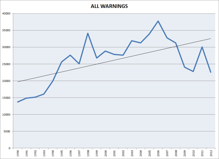
Does the change in hail criteria change the number of warnings issued nationwide?  Let's look at a plot, first, of total warnings since 1990.  We'll look at combined tornado and severe thunderstorm warnings since there is not a specific designation for hail warnings.
Warnings_1990to2012
Plot of combined tornado and severe thunderstorm warnings during the modern era 1990-2012. Black line is the trendline.
During the modern era, warnings have increased 167% from 1990 through 2012.  Much of this may be attributed to the installation of Doppler radar and trained weather spotters across the country.  From 1990 through September, 2007, the NWS office issued county-based warnings.  It was in October 2007 that polygon, or storm-based warnings were verified.
Warnings_2007to2012
Number of severe thunderstorm warnings from 2007 through 2012.
The plot above considers combined warnings from 2007 through 2012.  Again, in October 2007, storm-based warnings were verified.  This shows a decrease of 38% of warnings issued nationwide.
This could lead to the conclusion that changing the severe criteria to 1-inch diameter hail did decrease the number of warnings.  But, one must consider that 2011 was an unusually active year for tornadoes and severe storms.  Plus, damaging winds also plays a role in the issuance of severe thunderstorm warnings.  Convective winds of 50 kt (58 mph) or better meets severe criteria, as does wind damage.  Damage to large trees and outbuildings makes for a large array of considerations to issue severe thunderstorm warnings.

Monday, July 1, 2013

More on the Changes with the F/EF-Scale

     My previous blog talked about the distribution of tornado damage using the F/EF-Scale.  The main point here was how in the modern era (1990-2012) the distribution of violent damage was slow low (0.62%) after the occurrence of two tornadoes in Oklahoma where the damage was labeled EF5.  The tornado damage in Moore, OK after the May 20, 2013 tornado was based on the damage observed, while the El Reno, OK tornado was decided based on damage, but weighted by the measured wind speed using the phased-array radar on a Doppler on Wheels estimated the tornado produced 262 mph winds.  Note: the EF5 wind estimates are listed at 205+ mph.  Thus, the debate was on as two different methods were used to come to the damage rating.

     So, adding to this information and the previous blog, below is the fatalities by F/EF-Scale ratings of tornadoes during the modern era:

Fatalities 1990-2012 associated with F/EF Scale damage ratings.
    So, while the modern era still shows that 0.62% of violent tornadoes (EF4 or EF5), this type of destruction is associated to 61% of the fatalities.

     Let's look at the violent tornado months of April and May, 2011 which were the most active tornado months since 1953.  These months had 1084 tornadoes that resulted in 538 fatalities (see below).


These months included the tornado outbreaks that occurred over MS, AL and parts of GA April 27-29, and also the Joplin, MO tornado of May 22, 2011.  The damage in Joplin was rated as EF5 and resulted in 158 fatalities.

   During the months of April and May 2013, only 2% of the tornado damage was rated EF4 or EF5 (22 of the 1,084 tornadoes reported)


But, these tornadoes were attributed to 83.5% of the fatalities during these months!  This is an alarming figure considering how well-warned people were during many of these events.  Notice that 0.55% of the tornado


damage rated EF5 was linked to 53.5% of the tornado-related deaths!  And, by well-warned, there were moderate and high risks for severe weather issued by the NOAA Storm Prediction Center including several days of highlighted information days in advance, and many NWS Weather Forecast Offices issued hundreds and hundreds of warnings in association with these events.

So, how does this data and the previous data show any change between the F-Scale and EF-Scale?  We have much smaller numbers for EF5 damage than we used to.  We always stated that 1% of all tornadoes were rated the totally damaged EF5.  During the modern era, we have reduced that for the most part, and it's even less when you put aside the 2011 tornado year.  In 2013, we know of 2 tornadoes with EF5 damage: Moore, OK on May 20th and El Reno, OK on May 31st.  Assuming there are 1200 tornadoes on average, that is still 0.01% of all tornadoes that will still play a majority of the tornado fatalities.

Friday, June 21, 2013

Changes in the F/EF Scale in the Modern Era

I just posted the following graphic on Facebook:


I was interested in seeing how tornado damage has changed in the modern era defined as 1990-2012, the years that Doppler radar has been used for warning on severe thunderstorms that can or have produced tornadoes.  It's interesting to see that the tornado damage of EF5 was used 18 times since 1990.  Now, I need to put a little asterisk here seeing that the National Weather Service has only used the Enhanced Fujita Scale since February 2007, with the damage from the Greensburg, KS tornado being the first EF5.  So, actually, out of those 18 F5/EF5 damage tornadoes, only 8 tornadoes carry the illustrious EF5 moniker, while the others were rated F5 damage.

Now, F5 and EF5 are supposed to be similar ratings in order to protect the climatological record.  The F-Scale is a 1/4-mile wind originally used by Fujita (1971), while the EF-Scale is a 3-sec wind.  If you want all the juicy details see the Storm Prediction site at spc.noaa.gov/efscale.  

The EF-Scale is to take into consideration structural integrity and lately there has been discussion whether the Joplin tornado was worthy of the EF5 designation, see Mike Smith's blog here.  The fact remains that the EF-Scale, like its father, the F-Scale is subjective and carries an error of +/-1.  In most areas, this may seem trivial, but scientifically can mean the difference in an accurate database.

Now, for comparison, let's look at how the F-Scale faired from 1972-1989, prior to Doppler radar being widely used:


Note that from the inception of the F-Scale, which was widely used to survey the Super Outbreak of April 3-4, 1974, really for the first time, 0.10% of all tornado damage was rated F5.  Compare that to the modern era of 0.06% being rated F5/EF5 and it is pretty comparable, and this dataset includes Super Outbreak II that occurred April 24-28, 2011.

Saturday, March 22, 2008

Has it been since June 7 that I made an installment on the blog?  Well a lot has happened since June 7th!  

I was selected on July 2, 2007 as the new Meteorologist in Charge at the National Weather Service Forecast Office in Indianapolis, IN!!  Wow! First of all, what an opportunity to run a Weather Forecast Office!  Secondly, what a chance to live closer to family!  Recall that I am originally from Ohio ( I have two sisters in Ohio as well as several cousins) and my wife is from Wisconsin (she has much of her family in Wisconsin and Minnesota).

It was and is hard to leave Oklahoma after 11 years.  Our oldest, Danny, is a freshman at the University of Oklahoma, and we miss him terribly!  But, we also developed some close friends. Hey, Averyts, we miss you so much!  I do miss working at SPC, but things happen to us that God intends, and like my Mother always said, "Things happen for the best."  Knowing that God had this opportunity open to me must mean she was right!

I have enjoyed the new job.  New challenges, like learning several new segments to the job, i.e. budgets, counseling, leadership, aviation forecasting, AWIPS, radar and all that is exciting!!!  Just not enough hours in a day, and I would love to learn it all at once!  Like in the movie The Matrix where they download a program to learn how to fly a chopper and bang! they magically can do so as if they had 1000 hours flying time!  Boy, would that be great! 

But, everyone is doing fine in Indiana.  We look forward to new friends and having an easier time to visiting friends and family!

Sunday, June 17, 2007

Fear of Interviews...or Fear of Getting an Interview

I'm talking about JOB interviews. I ventured through Monster.com looking at questions for job interviews. The most fearful question?

What are your strengths? What are your weaknesses? It's 50-50 here. Go blank and you're dead.

Most interesting question? How many times to the hands on a clock overlap? Is that in a 12 or 24 hour period?

Why am I looking up questions for a job interview? Well, it's because I am hoping for one. See in my line of work, you apply for a promotion, you hope to be high on a list...high enough to be interviewed for the position. It sounds simple and can be. Or your name can be passed among others to be praised or smeared with the hope of being ranked to be interviewed.

So, what are your strengths and your weaknesses? Maybe one strength is knowing how many times the hand of a clock overlap.